 Road(s): Paved = High Park Road and Teller County One; both curvy in spots; Dirt = Phantom Canyon Road and Shelf Road; 4-wheel drive and high clearance recommended when wet, but is passable by 2-wheel drive in lower gear when dry.
Round-trip from Denver: 413 miles
Length of Byway: 131 miles
Vehicle types: Car, 4×4; dual sport
Elevation change: 4662 to 9,350 feet above sea level
Location: South Central Colorado
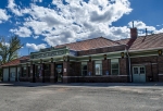
Cripple Creek
Base camp is what I called this wonderfully eclectic hamlet. We made it just in time for the annual Cripple Creek cemetery walks guided by artists, actors and actresses of the area all dressed in period garb. I loved it!
Unfortunately, my friend and I weren’t in Cripple Creek for the Mt. Pisgah Cemetery Tour, we were there to drive the Gold Belt Tour…crossing fingers. I say “crossing fingers,” because I wasn’t sure that my little ol’ 2-wheel drive Pontiac Vibe was up to the task of traversing a so-called 4×4 road, ie. Shelf Road. I thought I’d give it the ‘old college try’, though. I guess that’s a better way than explaining the technical aspects of driving a road that’s marked 4-wheel drive only by taking a front-wheel drive only car on it. I figured I’d drive as far as I thought I could handle it, er the “car could handle it” before turning around and heading back to ‘base camp’.
Backin’ It Up
Allow me to back this blog up a bit and fill you all in on the details before I get into the real fun…driving the byway.
I recruited the companionship of my co-worker and friend again for this byway tour. I knew she would be up for it, since she had so much fun on the Flattops Trail earlier in the summer. This time around, instead of wildflowers, we were hoping to get a glimpse of some of Colorado’s famous gold…um, aspen gold that is. And what better place to view some gold than smack dab in the middle of Colorado’s still running gold mine – CCnV. Well actually, we didn’t exactly try to descend into this particular mine to view aspen, but we did drive the roads that the miners use.
My friend and I decided that the last day of summer and the first day of fall would be prime time to not only view the changing aspen leaves, but also to celebrate the seasons. So, I booked us a room at the Hotel St. Nicholas and we left in the morning from Colorado Springs to drive the first part of the Gold Belt Tour Byway.
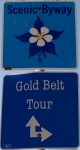
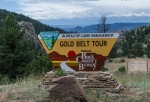
Gold Belt Tour Byway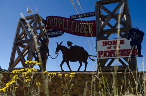

This particular byway needs a little bit of explanation, because it is actually four different roads that converge on the gold mining towns of Cripple Creek and Victor. Two of the roads, Phantom Canyon Road and Shelf Road are dirt roads. As I had discovered with all the research I did in advance of this tour, Shelf Road actually requires 4-wheel drive to travel this leg of the byway. As I dug a little further on the Internet and read some reviews of these roads, I discovered that some people also had enough chutzpah to attempt to drive Shelf Road in their 2-wheel drive vehicles. But…we all know that what people say on the Internet cannot be true…oh wait…strike that. Of course, I took it with a grain of salt, which is why my friend and I decided that if the road seemed really bad, we would turn around and come back to it when we actually were driving a 4×4.
Phantom Canyon Road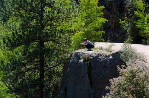

The morning started out wonderfully sunny and with a hot cup of coffee in hand, my friend and I were off on our jaunt westward into the mountains of Pikes Peak country. After we stopped at the visitor center in Cripple Creek to get a map of the Gold Belt Tour and learned a little bit about the roads, we were off on our journey to find the start of Phantom Canyon Road in Victor. What we learned at the visitor center was that it was advised that we drive both Phantom Canyon Road and Shelf Road from the north to the south, since drivers coming in the opposite direction have to make room for cars by hugging the edge of the road which sometimes plunges downward sharply several hundred feet.
Finding Phantom Canyon Road was a bit tricky though, because there really isn’t a clear sign with an arrow pointing, “This way to Phantom Canyon Road.” After a couple of U-turns, we finally settled on a dirt road on the northern edge of town which split off to a local lake and recreation area. We opted for the right leg of this split and were quickly relieved to find that we were on the correct road after we noticed the road number sign on the side of the road.
This road begins by meandering through some pasture and forested land, but as you round a bend in the road, the hillside drops off into a deep canyon. The road itself also narrows a bit at this point and stays that way for most of the rest of the journey as it travels along a days gone by narrow gauge railroad bed. The canyon is named ‘phantom’ canyon because the tall conical-shaped rocks dotted throughout the canyon tend to cast phantom-like shadows along the canyon walls as the sun is setting or rising. A few features of this canyon also include two old railroad tunnels which are wide enough for a car to drive through and a balanced rock which sits atop a Cliffside of about 100 feet.
Connecting Roads

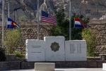
On the southern end of Phantom Canyon Road along the byway, sits the town of Florence. We stopped close to Main Street and visited the town museum which sits a block away from the Denver and Rio Grande train station. After leaving, we followed the byway through Canon City where we stopped again by the correctional facility. Yep, I said correctional facility. The Colorado Territorial Correctional Facility sits on the western end of town, right along the main thoroughfare…highway 50. As you round the bend of highway 50, you have to pay attention to the road sign which points you to the infamous Skyline Drive if you want to catch a glimpse of millions of years old dinosaur footprints along an ancient rock outcropping.
Skyline Drive not only features these newly discovered dinosaur footprints, but it is a one-lane road which traverses the top of what is called a hogback. These geologic features can be found up and down the Colorado eastern Front Range. The only one with a road that travels along its crest is the one at the western end of Canon City. Driving along this road not only provides you with breathtaking views, but a chance to see prehistoric history up close and personal. There are a few pullouts along this drive which make it easy to take in the beauty of the landscape.
High Park Road

After enjoying the views atop Skyline Drive, we continued our adventure along the Gold Belt Byway by heading north along High Park Road. As a side note, this road is fun to ride on a sport bike as well. But, this time, we drove the road in my lil ol’ Pontiac Vibe. All along this part of the byway, you pass mountain park land and historic ranches. One old ranch we passed as we took a turn northward had a particular draw for us, so I pulled over and waited for the sun to come out from behind some clouds to capture what I was seeing.
Teller County Road One
When you come to the end of High Park Road, it splits off into Teller County Road One at Evergreen Station. This two-lane paved road is the first stage route to Cripple Creek and is quite twisty and it winds through the mountainous terrain with its huge rock outcroppings jutting out between pine and aspen trees.
Cripple Creek
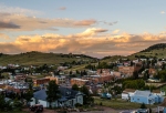
As we crested the last hill on the northwest side of Cripple Creek, I noticed the Mt. Pisgah Cemetery to the right where the cemetery walks would take place again on Sunday. Since my friend and I were keen on getting checked in to our hotel and taking advantage of the rooftop hot tub during the sunset, we chose to not stop anywhere until Hotel St. Nicholas. This particular hotel has quite the history, since it was first built as the areas general hospital in the late 1800s during the height of the Gold Rush. It is also considered to be haunted, which made our choice of lodging just a tad adventurous as well.
Although we did not have any ghostly encounters at the hotel, we did enjoy a spectacular sunset from the rooftop hot tub as well as one heck of a sunrise. Our room was located next to the hot tub area and faced west, so although the sun did not stream into the room in the morning, our western view gave us quite the mountain view vantage point as the sun’s morning rays slowly touched the mountain tops of the Sangre de Cristo mountain range.
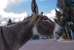
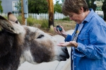
Remember what I said about this town being quite the eclectic hamlet? Well, after we had breakfast at the hotel, we also had our Cripple Creek donkey encounter. That’s right, I said donkey encounter. Since this area is the sight of the world’s largest gold camp, it only makes sense that some of the descendants of the donkeys used to haul supplies more than one hundred years ago in this area would still be roaming the hills. As a matter of fact, these particular donkeys are allowed to roam free throughout town because of their significance in the history of the area. Not only that, but the town holds an annual Donkey Derby Days to help raise funds to feed and care for these animals throughout the year.
Shelf Road
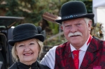
After hanging out with the donkey heard and stopping off at the Cripple Creek Museum to chat with the locals who were dressed in period garb for the cemetery tours, we made our way to the southern end of town to find the start of the last leg of our byway tour: Shelf Road. At first glance, this road looks like any other dirt road. It did not look like any of the 4×4 jeep roads I had been on in the summer with my hubby. Jeep roads tend to have rocks and boulders jutting out in the middle of the road, making it impossible for any vehicle except one with high clearance and low to mid-range torque to traverse it. I did not let the looks of the road get me overly confident though, because the area had also suffered from the same flooding rains that wiped out many roads in northern Colorado the week before. So, I took it slow and easy.
After about the first mile, I noticed that this road had a pretty fast descent from the Cripple Creek area. When we stopped to take some photos, we also had a different vantage point of the CCnV mine which showed us the huge gash in the mountain side that it had taken in order to extract gold. Both my friend and I were in agreement as we continued downward that if I came upon any area that I did not feel comfortable in trying to pass, then I would turn around and go back. As we drove, we came upon a couple on two ATVs heading in the opposite direction. The husband signaled for me to roll down my window and then asked me if I had been on this road before. I told him it was my first time and he said that the road below had been washed out in several places because of the rain. My friend and I looked at each other and again, we agreed that if I didn’t think we could make it, then I would turn around. So, I thanked the husband and we kept on going.
Before we got to the washout area, I imagined that there was a huge gash in the road which was only passable by ATVs, or a high clearance jeep. In my mind, I was picturing a jeep with big tires slowly inching down the gash, crossing a creek bed and then slowly going up the other side. At one point, just before a few technical hairpins in the road, I pulled over and looked down the canyon to see if I could see where the road went. Unfortunately, I couldn’t see anything, so again, I looked at my friend and said to her that I wanted to see what was down there and was thinking that if there was a wide enough area in the road and needed to turn back, then I would. Heck, I figured I could even drive backward if in dire need.
Again, we got back into my lil ol’ Vibe and continued downward as the road cut back and forth along the hairpins, it quickly descended as well and tightened up considerably. Then as we rounded a bend, I came upon the first washout area. To my surprise, this washout had already been filled in with softball sized rocks. As it turns out, this road is driven by many of the miners who work at CCnV and live in Canon City and it is the quickest route to and from the mine. So…of course the washouts were going to be filled in, albeit rough, it wasn’t that hard for my lil ol’ Vibe to slowly cross the rocks. While the Vibe is an automatic, it has manual 5-speed shifting as well, so I placed it into first gear before crossing. Still, I expected that somewhere down the road, within a mile or so that I would come across a part of the road which my car would not be able to deal with. To my surprise and delight, we just crossed the roughest part of the road and a few miles later, it smoothed out and became as easy to travel as Phantom Canyon Road was the day before.
The Shelf
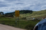
As we continued southward along the road, we came upon a sign which notifies drivers that the road narrows as it travels along the shelf and that only 4-wheel drives were advisable along this area. Again, I thought about it for maybe a second, but since we had come across a few 2-wheel drive cars going in the opposite direction, that thought was only fleeting. As we began traversing the shelf, we noticed that there were quite a few places along this one-lane road which you could pull out and turn around if necessary, as well as pull over and wait for oncoming traffic. More importantly though, were the views from this part of the road. Since we were on a shelf, it’s exactly as it sounds. This shelf is about two-thirds of the way up along a canyon wall. The drop-offs in some spots were drastic, but not as bad as other roads that I have been on, so I wasn’t worried at all. Although a sign warns of not stopping along the road, we stopped a few times to take pictures and take in the views which were quite spectacular. Traffic was non-existent at the time, anyway. After leaving the shelf, the road becomes paved again and the area opens up to ranch land surrounded by hillsides.
Last Stop

There’s one more unique feature along this byway: Red Canyon Park. This area is characterized by the same type of red rock feature you find in Garden of the Gods, but on a smaller scale. Another difference is that the red sandstone in this area is a very deep red. The only thing I did not like about this park was that the dirt road into the park had become severely rutted because of the rains from the week before. The fact that no maintenance seemed to have been done along this road was a tad disheartening. We did not go too far along this road because driving it was a whole lot worse than driving Shelf Road.
Final Impressions
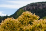
I was ecstatic that we were able to drive the full length of the Gold Belt Byway. Knowing that using a bit of caution and my car’s technical abilities, we could still drive along a road that warns drivers to use 4-wheel drive gave me a bit of a big head. One thing I would like to mention is that I probably would not have attempted this drive if it had been raining. I think mud would have been my car’s limit on the steep climbs along the route. Scenery and views of the Gold Belt Byway are top-notch, as well. My only regret is that we were not able to capture any aspen leaves in full color-changing mode. Many of the groves of aspen in the Cripple Creek area were still deeply green. So, it goes without saying…but, I will be back here again.


As executive director of this wonderful byway, I am surprised to hear you had trouble finding Phantom Canyon in Victor the way has been well marked. Also you keep saying that Shelf Road is advertised as 4 wheel drive our publications and website, says 4 wheel drive recommended when wet.
Other than that love that you had a wonderful time and enjoyed our beautiful byway
The entrance to Phantom Canyon from the south side is very well marked and hard to miss…but, on the north side from Victor, you see a huge sign at several crossroads, but then no other signs from those crossroads that point to Phantom Canyon. That was my problem. When you get to another fork in the road, the one the heads up to the reservoir or to Phantom Canyon, it would be great to see a sign that says, “Phantom Canyon” or place the byway sign right there on the right fork of the road.
Oh and on another bit of news, a friend of mine actually traveled both Phantom Canyon and Shelf Road by dual sport on the last weekend of October. He loved the scenery as well. 🙂